Elevation: 250m
Parking: 46.9768°, 5.9996°
Ferrata: 46.9796°, 6.0033°


Characteristics
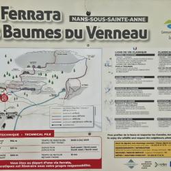
A beautiful via ferrata park with views over the valley. This section, “Parcours Difficile”, is designed for advanced via ferrata climbers. Caution: even the descent is rated difficulty D, and there are overhangs on the way down — do not remove your via ferrata set during the descent! The D descent section can be bypassed via a B route, or climbed separately in the upward direction and then descended again.
The route begins with a section rated B to C/D, where the zipline is located. After descending the zipline, you can reconnect at the point where the C/D-rated section continues (note: this connection is not marked on the map).
It is followed by a shared section with the “Peu difficile” (easy) route. Along the hiking trail, the route splits. The D variant leads to the highest point of the via ferrata over a distinct but not overly difficult overhang.
The descent then takes us down a D-rated section, which is likely the crux of the route, as you must overcome a small overhang where you can’t even see the footholds. (You can bypass this with the classic B route or climb it from below.)
Arrival
The fastest and most affordable route is via Germany to the city of Besançon, and then to the village of Nans-Sous-Sainte-Anne. Parking is available south of the church.
Approach
Head north toward the visible rock face. Walk around the church and follow the alley at the intersection. Pass a stand where you can rent equipment, then continue up the forest path.
Descent
Follow the well-trodden path back to the rental stand, then return to the parking lot.
Points of interest
(Multiple authors)


 © 2026 Ferrata Guide