Good condition
Elevation: 720m
Parking: 46.6563°, 12.4198°
Ferrata: 46.642°, 12.4115°


Characteristics
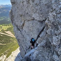
2,5 hrs – level C/D The entrance to the via ferrata is situated within a small debris chute where the steel cable begins. The trail starts off with a challenging section (D), proceeding along a steep rock pillar (C/D) with relatively consistent difficulty.
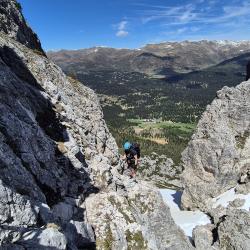
Following the initial demanding third, the path transitions into easier terrain (A/B) until you reach the Arzalpenturm Ridge after a traverse (C) and a steep step (C/D).
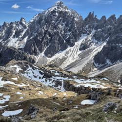
Upon crossing the ridge, you’ll arrive at a small saddle next to the actual summit of Campanile Colesei. Here, there is a one-way regulation. Access to the true summit of the tower requires an additional variant. Descend from the saddle along the south-facing steel cable (C). Shortly, you’ll encounter a junction where the variant is indicated. If you like, you can ascend Campanile Colesei (C/D) and return to this point in a complete circuit. From the junction, follow the path downward to a saddle (C), where the steel cable on the opposite side ascends to the plateau of Croda Sora I Colesei (C).
Arrival
The via ferrata can be easily be reached from two different starting points. Depending onwhether you come from South Tyrol or Belluno, both Passo Monte Croce and Rifugio Lunelli serve as excellent starting points.
Approach
From Passo Monte Croce (1.636m) 450 m – 1,5 hrs Follow trail no. 124 southward from Passo Monte Croce until you reach Forcella Plan della Biscia (1,942 m) near Cima Colesei. Proceed along the old and broad road from the war after reaching the forcella. A few 100 meters past a distinctive curve, you’ll encounter a sign and a little stone man. Turn left from this point (2,010m) to reach the starting point of the via ferrata. While the path may not be heavily traversed, it is marked with red dots. It is recommended to wear a helmet, especially in the final section, where you are positioned just below the via ferrata and face a higher risk of falling rocks.
From Lunelli Hut (1.568m) 510 m – 1,5 hrs From the hut you climb up to the Forcella Plan della Biscia (1,942 m) via path no. 171 or alternatively via the wide path no. 155. From there you continue along the old and wide road from the war. A few hundred meters after a prominent curve, you will find a sign and a small stone man. From there you turn left (2.010m) to arrive to the attack of the via ferrata. This climb is not yet well trodden on, but is marked with red dots. It is advisable to wear a helmet in advance, as in the last section you are just below the via ferrata and therefore exposed to a greater risk of falling rocks.
Starting from the hut, ascend to Forcella Plan della Biscia (1,942 m) either via trail no. 171 or, alternatively, the broader path no. 155. From the forcella, proceed along the old and broad road from the war. After navigating a distinctive curve a few hundred meters ahead, you’ll encounter a sign and a small stone cairn. A few 100 meters past a distinctive curve, you’ll encounter a sign and a little stone man. Turn left from this point (2,010m) to reach the starting point of the via ferrata. While the path may not be heavily traversed, it is marked with red dots. It is recommended to wear a helmet, especially in the final section, where you are positioned just below the via ferrata and face a higher risk of falling rocks.
Descent
To Passo Monte Croce via Forcella Colesei
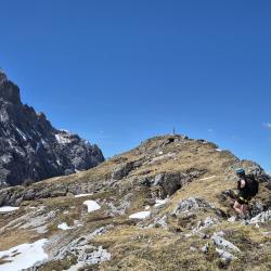
600 m downwards – 1,5 hrs Upon exiting, follow the trail marked by red dots to the west, and after a short distance, you’ll encounter a signpost. Ascend in a northeastern direction from here to reach the panoramic summit of Arzalpenkopf (Cima Sora Colesei) at 2,291m. Descend back to the signpost and continue along the path to the west towards Forcella Colesei. From there, the trail descends northward along a partially secured path. As you reach the end of the scree, connect with path 15, which leads you to Passo Monte Croce. The area below Forcella Colesei often retains old snow until summer; in such cases, it is advisable to choose the descent via Sentiero Sala.
To Passo Monte Croce via Sentiero Sala
680 m downwards – 80 Hm uphill – 2 hrs Upon completing the via ferrata, track the trail marked with red dots to the west. After a short while, you’ll encounter a signpost. Proceed by following the path southward toward the Rifugio Berti. At the Rifugio Sala, diverge at another signpost onto the Sentiero Sala (124). Continue along this partially secured path until you reconnect with the initial route, which guides you back to Passo Monte Croce.
To Lunelli Hut via Rifugio Berti
680 m downwards – 2 hrs After exiting, follow the trail marked with red dots to the west, and shortly, you’ll arrive at a signpost. Proceed by taking the southern path towards the Rifugio Berti (1,950m), a welcoming spot for a break. Continue along path 101 to reach the Lunelli Hut.
Points of interest
INSIDER TIP There is a fortress tunnel through Croda Sora i Colesei, constructed between the two World Wars. To explore it, follow the route described above in the direction of Passo Monte Croce via Forcella Colesei. In the lower third of the debris field, you’ll notice tunnel entrances on the right side. Access the tunnel through the easiest entrance, follow it to the other end, and upon exiting, trace the original path or take the wider route to Forcella della Biscia. Descend from there using the same route as during the ascent. Please note that this bunker is not publicly marked or signposted, and entering it is at your own risk. This variant adds approximately 40 minutes to the tour.
(Multiple authors)


 © 2026 Ferrata Guide