Guter Zustand
Topo: Kein Topo :(
Höhenunterschied: 30m
Parken: 44.7563°, 6.7932°
Klettersteig: 44.7556°, 6.792°


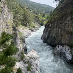


Beschreibung
Der Klettersteig ist von leichterer Schwierigkeit und führt über den Fluss Guil, er ist für Anfänger und Kinder geeignet. Er verläuft durch eine wunderschöne Schlucht mit blauem Wasser unterhalb des Schlosses, wo Kanuten unter Ihnen fahren. Es gibt eine 5 Meter lange Affen-Brücke und eine 30 Meter lange Nepalesische Brücke. Es gibt zwei Notausstiege, daher sollten Sie diese nicht mit dem Ende des Steigs verwechseln und weitergehen. Der Schwierigkeitsgrad B/C ist nur auf einem kurzen Abschnitt. Auf dem größten Teil des Weges gibt es Steighilfen für Beine und Hände.
Anfahrt
Mit dem Auto zum Dorf Château-Queyras, wo es einen großen Parkplatz für Paddler und Ferratisten gibt. Das Parken ist kostenlos.
Zustieg
Vom Parkplatz über die Brücke und nach der Brücke rechts zum Start-Schild.
Abstieg
Folgen Sie der Asphaltstraße zurück zur Brücke und zum Parkplatz.
Wissenwertes
2014 - Der Steig wurde geschlossen, der Besitzer des Schlosses und des Landes verlangte eine Zahlung von der Gemeinde, weil der Steig durch sein Eigentum verläuft.
2015 - Eine neue Route wurde auf der anderen Seite des Flusses außerhalb des Schlossgeländes gebaut und wiedereröffnet.
(Mehrere Autoren)


 © 2026 Ferrata Guide